
What to Know
- A flood watch is in effect until 9 p.m., but most heavy rain will be before noon, NBC 7's Sheena Parveen said
- Flood warning is in effect until just after midnight for the San Diego River in the Fashion Valley area
- Tuesday: A chance of rain persists in the morning followed by mostly cloudy skies
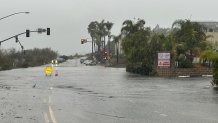
A chilly winter storm that arrived in the San Diego area over the weekend delivered more steady downpours Monday along with widespread flooding that swamped roadways and neighborhoods across the region.
In the late morning, with rainfall rates approaching a half-inch per hour, the National Weather Service issued a flash-flood warning for the western valleys and the ocean coastline of the county.
State of Emergency declared
Get San Diego local news, weather forecasts, sports and lifestyle stories to your inbox. Sign up for NBC San Diego newsletters.
By Monday afternoon, San Diego Mayor Todd Gloria declared a State of Emergency due to the storm's impact.
"We have activated the City’s Emergency Operations Center, and our emergency responders will continue to address the impacts around the clock. The American Red Cross has set up an evacuation center at Lincoln High School for residents who have been displaced by the flooding," the mayor said.
“I strongly urge residents to please avoid any flooded areas and any unnecessary travel," Gloria added.
Late on Monday night, the County of San Diego proclaimed a local emergency on behalf of the Board of Supervisors since they anticipated resources and assistance to arrive from the state and federal government due to the damage from Monday's flooding.
A lot of rain all at once
From 6 a.m. to noon on Monday, the San Diego International Airport got 2.48 inches of rain. That means the city got a quarter of its normal yearly amount of rain in just one six-hour stretch, according to NBC 7 meteorologist Greg Bledsoe.
San Diego has gotten more rain over the past three days, than during the past three months combined. In fact, that amount has almost doubled.
Rainfall totals
As of 3:03 p.m. on Monday, rain totals reached high amounts, according to the NWS of San Diego.
The National Weather Service of San Diego reported that Monday was the fifth wettest day in San Diego since 1850.
Top 3-day rainfall totals as of 3:03 p.m. on Monday (from highest to lowest)
- Santiago Peak: 5 inches
- Otay Mountain: 4.51 inches
- Point Loma: 4.49 inches
- National City: 4.21 inches
- Palomar CRS: 4.01 inches
- La Mesa: 3.89 inches
- Fallbrook: 3.40 inches
- Birch Hill: 3.39 inches
- Dulzura Summit: 3.38 inches
- Palomar Mountain: 3.31 inches
To view more rainfall totals, we have a story here:
A flood watch is also in effect from 9 a.m. to 9 p.m. Monday for all areas of the county, according to the NWS. A flood advisory was in effect until 12:30 p.m. for northern portions of San Diego County deserts.
A flood warning is in effect until just after midnight for the San Diego River in the Fashion Valley area.
Most of the heavy rain was expected to take place before noon on Monday, NBC 7 Meteorologist Sheena Parveen said.
Flooding incidents, rescues
The heavy rain has caused over a dozen accidents in the Monday morning commute on the road as shown in the map posted by the NWS of San Diego below:
There were flooded roadways, several car crashes and water rescues. We have a breakdown of all storm-related damage here:
There were also several outages reported around the county Monday afternoon amid the powerful storm but SDG&E was assessing the cause.
Other stories worth checking out


Tuesday weather overview
A chance of rain persists on Tuesday morning followed by mostly cloudy skies.
Next weekend looks to be warmer with temperatures making a return for the 70s in the coasts and valleys.
Those showers could linger into Tuesday before drying out and warming up for the rest of the week.
