
Cooler conditions are in store for San Diego County Saturday, with patchy low clouds sticking around the coast into the afternoon and gusty west winds continuing in the mountains and deserts, the National Weather Service said.
"We will start today with morning marine layer clouds for coastal areas and western inland valleys. Those will mix out through the mid to late morning hours," NBC 7's Meteorologist Brian James said.
A warming trend was expected Sunday and Monday, with cooler conditions and increased onshore flow returning for the middle part of next week. A stronger storm system could bring precipitation to the region sometime late next week.
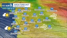
High temperatures along the coast Saturday were predicted to be 65 to 70 degrees with overnight lows of 49 to 54. Valley highs were expected to be 66 to 71 with overnight lows of 43 to 51.
Get San Diego local news, weather forecasts, sports and lifestyle stories to your inbox. Sign up for NBC San Diego newsletters.
Highs in the mountains were expected to be 58 to 68 with overnight lows of 38 to 44, and highs in the deserts will be 83-88 with overnight lows of 53 to 60.
Another weak trough was expected to push through the Pacific Northwest on Tuesday and Wednesday, resulting in a cooling trend for all areas, gusty west winds in the mountains and deserts, and increased high cloud coverage, the NWS said.
West winds were forecast to be gusty each afternoon and evening, with the winds on Tuesday looking to be the strongest. Peak gusts to 60 mph were possible in the passes and canyons Tuesday afternoon and evening.
Cooler and breezy conditions were expected to continue into next weekend.
On the outer coast, gusts of 20 to 25 knots were forecast to develop each afternoon and evening through Wednesday. Highest gusts were predicted to be Monday and Tuesday.
Local


Get updates on what's happening in San Diego to your inbox. Sign up for our News Headlines newsletter.
