
A powerful winter storm system that dumped rain and snow on San Diego County overnight moved out of the region Wednesday, but it left behind record-breaking cold temperatures across the county.
The National Weather Service in San Diego said multiple regions in Southern California, including Vista, El Cajon, Palomar Mountain and Lake Cuyamaca experienced record-low maximum temperatures.
Rainfall records were also set in Ramona and Campo.
Get San Diego local news, weather forecasts, sports and lifestyle stories to your inbox. Sign up for NBC San Diego newsletters.
The system moved in Tuesday and brought sweeping downpours, powerful wind gusts and mountain snow at low elevations.
Here are the snowfall totals in San Diego County as of 9:30 p.m. Wednesday:
- Mt. Laguna (6,000 feet): 14 inches
- Birch Hill (5,700 feet): 13 inches
- Palomar Observatory (6,100 feet): 10 inches
- Palomar Mountain (5,500 feet): 7 inches
- Julian (4,150 feet): 6 inches
- Descanso (3,400 feet): 1 inch
- Campo (2,600 feet): .5 inches
Some chain control requirements are still in place on State Route 78 and SR-79. Follow the latest with this map from Caltrans (Click options, road conditions then chain control).
As for the rest of the county, 3-day rainfall totals crept past 2 inches for some areas. Get the latest rainfall totals here.
"Aside from the rain, we'll also be dealing with cold temperatures that will be heading our way later tonight," NBC 7 Meteorologist Sheena Parveen said. "We have a frost advisory for the coast, a freeze warning for the inland valleys, expect very cold temperatures also for the mountains and the deserts."
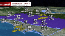
The frost advisory and freeze warning were in effect from midnight to 8 a.m. Thursday. During that time, temperatures could fall as low as 34 degrees along the coast and 28 degrees in the valleys overnight.
Local


There will be no more rain in February, according to forecasters, and a slight warm-up is set to begin Thursday.
