
A powerful storm system that slowly made its way to San Diego County finally arrived overnight Friday with thunderstorms and heavy rain that caused some flooding and prompted at least one rescue while most of San Diego was asleep.
Thunderstorms moved in around midnight bringing flashes of lightning and heavy bursts of rain to most parts of the county, particularly along the coast. The National Weather Service recorded 31 cloud-to-ground lightning strikes in San Diego County and more than 130 lightning bursts over coastal waters.
Weather updates to watch for
Get San Diego local news, weather forecasts, sports and lifestyle stories to your inbox. Sign up for NBC San Diego newsletters.
While the brunt of the system hit San Diego overnight, the system lingered over San Diego during the afternoon and nighttime on Friday, bringing with it scattered showers, and is expected to exit by Saturday afternoon, according to NBC 7 meteorologist Francella Perez.
For the rest of Friday evening, rain will come in the form of isolated and light rainfall mostly over the inland mountains, Perez said.
For the rest of the county over Friday evening, expect stray showers. Plus, mountain and foothill dwellers should watch for isolated thunderstorms on Friday evening.
Local


Additional rainfall through Saturday morning is expected to range between 0.10 to 0.30 inches for the coast and valleys, while the mountains should get up to 0.75 inch and deserts up to 0.25 inch, Perez added.
In the meantime, a flood watch remains in effect until 10 p.m. on Friday.
"By tomorrow morning, things will begin to gradually dry out as a storm system begins to exit and lift towards the east," Perez said.
The weather is expected to warm up over the weekend before Christmas, making way for a gradual warm-up into the middle of next week, after Christmas.
Don't put your umbrellas and rain boots away just yet — another storm system may hit toward the end of the month. As with all weather forecasts, that may change and we'll keep readers updated as we get closer.
Pacific storm soaked San Diego overnight. Here's how much rain fell so far
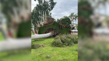
City preparations and damages
The city of San Diego had been working for the last several days to prepare for this portion of the storm by closing streets that are prone to flooding. Several streets were closed in the Mission Valley area, and some near Fashion Valley remained closed Friday afternoon.
A woman and her dog had to be rescued from a storm channel in El Cajon early Friday as they were caught in flood waters. Heartland Fire told NBC 7 the woman was taken to a local hospital. Her condition is unknown.
In Carlsbad, a couple of roads were closed temporarily overnight due to "multiple road hazards caused by the storm," Carlsbad Police said. By 5:45 a.m. the roads were reopened for the morning commute.
Even though most of the rain is through, some streets and areas near rivers could still experience flooding. A flood watch was still in effect until Friday afternoon.
The storm system started light, with just a few scattered showers on Tuesday and Wednesday. The heaviest showers reached the region late Thursday, bringing isolated thunderstorms.
Some regions like Point Loma received up to 0.63 inches of rain and Shelter Island saw 0.64 inches of rain overnight, according to the National Weather Service.
Christmas Eve, Christmas Day weather
As we head into Christmas Eve weekend, NBC 7 meteorologist Sheena Parveen said we can expect Sunday to be dry and a little cool at night with the coast in the high 40s. On Christmas Day, will mostly be sunny, with upper 60s along the coast.

