
A large, cold storm system is moving through the West Coast bringing rain, high surf, and gusty wind to San Diego County on this November weekend.
NBC 7 meteorologist Sheena Parveen said there would be an increase in the surf and rip currents at San Diego’s beaches through the weekend signaling the storm moving in.
High Surf at San Diego's Beaches
To that end, the National Weather Service said a Beach Hazard Statement will be in effect from 8 a.m. Friday through 2 a.m. Monday. Waves and surf are expected to be between 4 and 6 feet, with local sets to 7 feet. The NWS said the highest surf is expected Saturday afternoon through Sunday evening.
This will create hazardous swimming conditions at local beaches, so the NWS said all swimmers and surfers should obey posted signs and flags and speak to lifeguards before getting into the water. The agency said minor tidal overflow and even some lightning are possible at San Diego’s beaches during the weekend storm.
"Surf will be elevated today through the weekend. Expect dangerous rip currents with wave heights 4-6 feet, some sets near 9 feet," NBC 7's Meteorologist Crystal Egger said.
Local


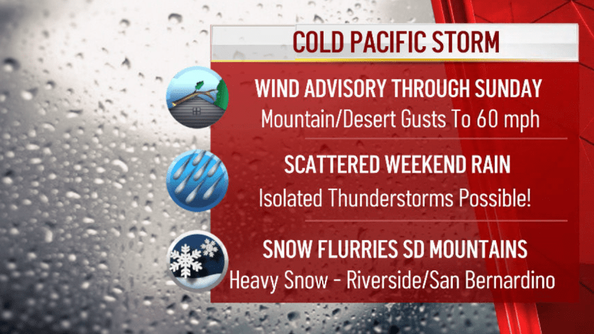
Wind Advisory
Meanwhile, over in San Diego’s mountains and deserts, Parveen said locals should expect a blustery weekend. The NWS said a Wind Advisory goes into effect in those areas at 12 p.m. Friday and will last through 10 p.m. Sunday.
The advisory will bring southwest winds between 20 and 30 mph and gusts near 50 mph or higher, Parveen explained.
The NWS said gusty winds could blow down tree limbs or power lines. Anyone driving in the mountains or deserts this weekend should use extra caution in the windy conditions – especially if driving a high-profile vehicle.
Those gusts got really strong on Saturday, the NWS said.
Free Sandbags Ahead of Storm
The City of San Diego said it would provide residents with free empty sandbags ahead of the storm. The sandbags are in limited supply and can be picked up at nine recreation centers centrally located in each City Council District.
The San Diego Weekend Storm: A Timeline
Friday, Nov. 6: Parveen said winds will increase in San Diego’s mountains and deserts Friday night and may even come with a chance of a few light showers.
Then, the chill.
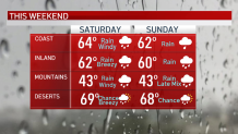
Saturday, Nov. 7: Parveen said Saturday will be breezy and chilly across the county, with showers moving in.
“It’ll be breezy at coast and inland, gusts near 20 to 30 mph,” Parveen said. “It’ll be windy in the mountains and deserts with gusts near 50 mph. We’ll see scattered rain showers throughout the day.”
Parveen said Saturday’s temps are expected to be in the 60s near the coast and inland and chilly 40s in the mountains, so San Diego will experience that fall sweater weather for sure.
Egger said rain totals are expected to be scattered due to the nature of this event.
"Expect a half-inch to 2 inches from the coast to inland valleys, 2 to 4 inches in the mountains and less than one-quarter inch across the deserts," Egger said.
By 1:45 p.m. Saturday, the NWS said scattered showers were persisting across the county and would continue through the afternoon before tapering off overnight.
But the cold storm wasn't over just yet.
Sunday, Nov. 8: On Sunday, there’s still a chance for more rain. Parveen said the winds will taper off that night in the mountains and deserts. And then, San Diego’s mountains may even see a little bit of snow.
“Our mountains may see a brief change over to wintry mix or snowfall above 6,000 feet late Sunday,” Parveen said.
Mountains may see a brief change to wintry mix or snowfall above 5,000 feet late Sunday.
In the Sierra Nevada, Parveen said snow will fall as a winter storm warning moves into that region through 4 p.m. Sunday. The Sierra Nevada is expected to see between 6 and 12 inches of snowfall above 5,000 feet and 12 to 15 inches above 7,000 feet. Skiing, anyone?
What Comes After the Storm?
The NBC 7 First Alert Forecast shows the storm clearing as we head into Monday.
Parveen said it’ll be dry next week, but still quite cool.
“It’s going to be feeling a lot more like fall around here,” she added.
It's going to feel a lot more like fall around here.
Sheena Parveen, NBC 7 Meteorologist
Get NBC 7's latest weather updates here.
