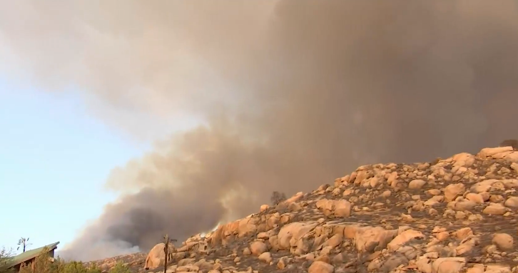
More residents in the Fairview Fire area near Hemet are under evacuation orders Thursday as the deadly wildfire grew to nearly 24,000 acres, with no change in containment despite an intensified response from firefighters struggling to slow the flames.
The fire started Sept. 5 and on Thursday authorities gave an update asking residents in areas surrounding the fire that includes parts of Temecula on the border with San Diego County to prepare to evacuate.
Fire officials asked the residents to prepare to evacuate at any time.
"We have 48 to 72 of a hard firefight in front of us and after that or sometime in between that, potentially immediately shifting gears to potentially devastating rain totals," Reyes warned.
Get San Diego local news, weather forecasts, sports and lifestyle stories to your inbox. Sign up for NBC San Diego newsletters.
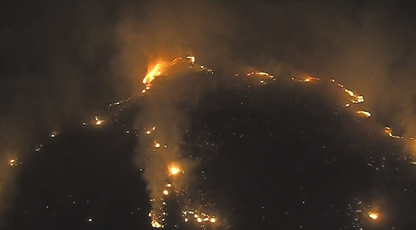
"I haven't seen a fire burn like that in Riverside County in my career. It's a very stubborn fire. It's doing things that we just haven't seen," said Temecula City Division Chief John Crater, responsible for De Luz, La Cresta, Aguanga, and the San Diego County border. "If we get fires from the east, the fire is going to affect us ... we are preparing to evacuate 22,000 people from an area. Traffic is going to be heavy. Please when we ask you to evacuate, do so in an orderly manner."
The city of Temecula has opened two temporary shelters at Valley High School, and the second at Temecula Community Center.
Perris Fairgrounds, located at 18700 Lake Perris Drive in Perris (92571) has opened to set up an emergency shelter for large animals. (Livestock users should use Avalon Parkway to access the stables)
Take a look at areas under evacuation orders and warnings below.
Evacuation Orders:
9/8/22 8 p.m.:
South of Diamond Valley Lake, East of Washington St., North of Borel Rd., East of Rancho California Rd, East of Anza Rd., North of Temecula Pkwy (Hwy79), Northwest of Hwy 371, and West of Springbrook Rd.
9/8/22 1:18 p.m.:
East of De Portola Road, West of Sage Road, North of East Benton Road and South of Diamond Valley Road. Interactive Evacuation Map: www.RivCoReady/AlertRivCo
9/7/22 11:45 p.m.:
South of Minto Rd., South of Red Mountain Rd., West of Stanley Rd., and North of Stanley Rd., East of Sage Rd.
9/7/22 10 p.m.:
West of Wilson Way, South of Hwy 74, East of Fairview Ave., North of Stetson
9/7/22 4 p.m.:
South of Cactus Valley RD., North of Minto way, North of Red Mountain RD, West of US Forest Service Boundary, and East of Sage Rd.
9/6/2022 4:45 p.m.:
Thomas Mountain Ridge South to Cactus Valley to Bautista Cyn to forest boundary.
9/6/22 12 p.m.:
Bautista Canyon Road, south of Stetson Road, north of the Two Streams trailhead
Evacuation Warnings:
9/8/22 12 p.m.:
South of Rawson Road, East of Washington Street, North of Borel Road, East of Rancho California Road, East of Anza Road, North of Temecula Parkway (HWY79), Northwest of Highway 371 and West of Highway 74.
9/7/22 11:45 p.m.:
East of Sage Road, West of Reed Valley Road and West of the Forest Service boundary, South of Stanley Road, and North of Wilson Valley Road.
East of De Portola Road, West of Sage Road, North of East Benton Road, and South of Diamond Valley Road.
9/7/22 10 p.m.:
West of Fairview, South of Hwy 74, North of Stetson, East of Soboba St.
East of Fairview, North of Hwy 74, South of San Jacinto River bed, East of Wilson Way.
9/7/22 4 p.m:
East Red Mountain RD, and the Cahuilla mountain US forest service boundary
South of Minto Way, South of Red Mountain Rd, West of Stanley Rd., and North of Stanley RD., and East of Sage Rd.
9/6/2022 6 p.m.:
Evacuation Warning. South of Cactus Valley Rd, East of Sage Rd, North of Red Mountain Rd. West of Bautista Canyon in Sage.
9/6/2022 4:45 p.m.:
South of Hwy 74 to Thomas Mtn. W of Mountain Center N of Cactus Vly. Anza N of Hwy 371 to Forestry Boundary.