
A strong Pacific storm rang in the New Year in San Diego County, with more on the way , according to the National Weather Service
The rain was heavy at times overnight and high snow levels could keep most accumulating snow above the mountain resorts, the NWS said.
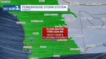
A flood watch was in effect from 6 p.m. Saturday to 2 a.m. Sunday for San Diego County coastal areas, mountains and valleys. A wind advisory was posted from 8 p.m. Saturday to 4 p.m. Sunday for coastal areas, deserts, mountains and valleys.
Get San Diego local news, weather forecasts, sports and lifestyle stories to your inbox. Sign up for NBC San Diego newsletters.
"The storm will move out as quickly as it moves in," the NWS said. "This should make for a quiet Monday with some sun, but continued cool weather."
The Stormwater Department will be temporarily placing "no parking" signs in low-lying or flood-risk areas, cleaning storm drains and inlets with a history of debris buildup, street sweeping to reduce trash and pollutants from entering our waterways and monitoring more than 46,000 storm drains citywide for any issues. Sandbags will also be available for residents.
Local


Most local temperatures Saturday were expected to be in the 60s, with overnight lows in the upper 40s and lower 50s. Highs in the mountains were expected to be in the 50s with lows of 33 to 41, and highs in the deserts were forecast to be in the lower 70s with lows of 46 to 56.
Small streams and normally dry creek beds were expected to start flowing with water. Some minor rises in the county's main rivers were likely as well. The rise in the San Diego River could be sufficient to overtop a few of the low-water crossings in Fashion Valley on Sunday.
Strong winds and hazardous seas were expected Saturday evening through Sunday evening. Northwest winds of 20 to 30 knots with gusts of 35 to 40 knots were expected over the coastal waters. A gale warning was posted for the outer and inner waters. Combined seas of 10 to 15 feet were likely Sunday, highest in the outer waters.
A west-northwest swell of 10 to 15 feet at 8 to 10 seconds could produce high surf at the beaches Sunday through Monday, with sets of 5 to 8 feet. Higher sets to 9 feet could occur in southern San Diego County.
A high surf advisory will be in effect Sunday through Monday. Surf will gradually diminish Monday, though more Pacific storms could bring elevated to high surf Wednesday through Saturday of next week.
