Incredibly, two earthquakes hit one second and about 60 miles apart over the weekend, according to the US Geological Survey
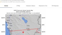
The first quake, which was a magnitude 3.4, struck about 5 miles west-southwest of Tecate, in Baja California, at 38 seconds after 5:13 p.m. on Sunday. That's about 85 miles from downtown San Diego, and just a few miles from the U.S.-Mexico border. The quake's epicenter was in an unoccupied area, but nearly 14 miles down.
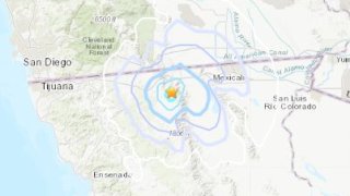
Then, almost immediately after, a quake shook the Mexican desert about 18 miles southwest of the town of Ocotillo, in California. This quake had a magnitude of 3.6 and was very shallow — just over half a mile down — and could possibly have been felt by residents of the Mexican city of Mexicali, to the east.
Get San Diego local news, weather forecasts, sports and lifestyle stories to your inbox. Sign up for NBC San Diego newsletters.
The most recent earthquake felt in San Diego County before Sunday's pair of temblors was on March 31, 2023, when a 4.5 magnitude event shook up the area around Palomar Mountain during the afternoon.