
When it comes to rainfall, California has already had an active start to the year.
Since the water year began on Oct. 1, San Diego International Airport has received 8.82 inches of rain. That's compared to the annual average of 9.79 inches. That means this part of the county is 1 inch away from reaching its average.
In San Diego, February is typically the wettest month of the year, according to NBC 7 meteorologist Brooke Martell.
"We're used to accumulating about 2 and a quarter inches of rain during that time," she said.
Get San Diego local news, weather forecasts, sports and lifestyle stories to your inbox. Sign up for NBC San Diego newsletters.
San Diego International has already received about 4 inches of rain throughout February.
Martell says that with the amount of rain we've received — not just within this water year but even since last winter — we've done pretty well with our drought monitor.
"We only have about 7.2% of the state in abnormally dry conditions, not even drought conditions," she said. Those areas include north of Redding, east of Sacramento and southeast of Barstow.
Local


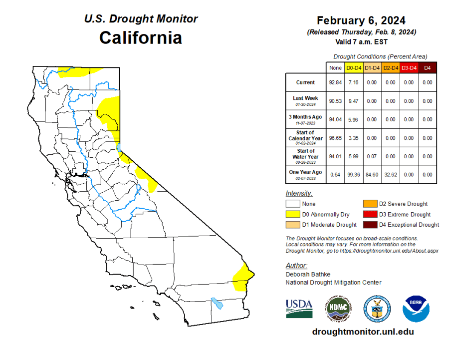
According to the U.S. Drought Monitor, less than 1% of California-Nevada remains in drought, compared to 100% a year ago. This means a 5-drought class improvement in areas such as the Central Valley. Most recently, parts of southeastern California and adjacent Nevada and Utah saw drought removal/improvement due to heavy rainfall from Hurricane Hilary and its remnants.
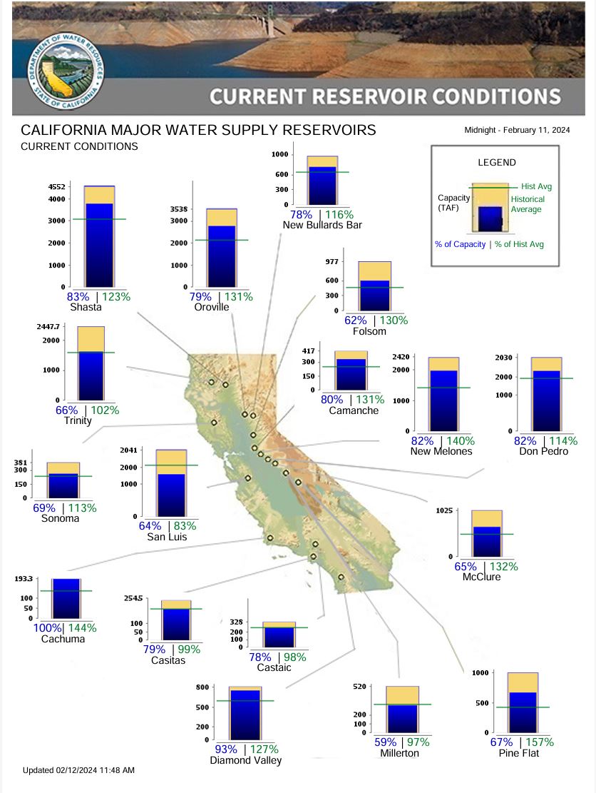
Still, the big question remains: What about California's reservoir levels?
Reservoirs throughout the region are at or above historical averages going into Water Year 2024.
Shasta Lake, one of the state's largest reservoirs, is currently at about 83% capacity, which is about 123% of its historical average, Martell explained. Lake Don Pedro is at a similar capacity, and other reservoirs across California are not doing too badly either.
What is an atmospheric river?
The term atmospheric river is defined as narrow areas in the atmosphere that transport significant amounts of moisture to areas outside of the tropics. It’s like a river in the sky, Martell said.
While atmospheric rivers can vary greatly in size and strength, the average atmospheric river carries an amount of water vapor roughly equivalent to the average flow of water at the mouth of the Mississippi River, according to the National Oceanic Atmospheric Administration (NOAA). When the atmospheric rivers make landfall, they often release this water vapor in the form of rain or snow.
One particular atmospheric river you may have heard of on the West Coast is sometimes referred to as a Pineapple Express. The jet stream in the sky transports humid air from the Hawaiian Islands toward California. Because the stream is filled with moisture, it can bring torrential downpours to California and heavy snow to the Sierra Nevada in the winter months.
On the West Coast, particularly in California, most of the incoming rainfall is associated with atmospheric rivers, and it falls during only a few storms a year, Dr. Anna Wilson with The Center for Western Weather and Water Extremes at Scripps Institution of Oceanography told NBC 7 via email.
NOAA said about 30-50% of annual rainfall in the West Coast states accumulates with just a few atmospheric river events.
Like NOAA, Wilson said atmospheric rivers can provide 50% more of California’s water supply and can cause the most flood-related damages -- up to 84% in the 11 western states and up to 99% at the coast.
