
Clouds were predicted to gradually decrease Sunday afternoon over San Diego County, except for lingering stratus at the beaches, the National Weather Service said.
Temperatures looked to be near or slightly below normal, mainly near the coast, for the rest of the Fourth of July.
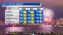
For any fireworks viewing Sunday evening, most of the coastal clouds should be around 1,000 feet above the ground, while most areas more than 5-10 miles inland should be clear, forecasters said.
Get San Diego local news, weather forecasts, sports and lifestyle stories to your inbox. Sign up for NBC San Diego newsletters.
High temperatures along the coast Sunday were expected to be 69-94 degrees with overnight lows of 58-63. Western valley highs will be 78-83 and highs near the foothills will be 87-92 with overnight lows of 57-62.
Mountain highs were predicted to be 88-94 with overnight lows of 60-70. Highs in the deserts will be 107-112 with overnight lows of 79-85.
Building high pressure this week was predicted to bring some warming to inland areas, the NWS said.
Local


Moisture was expected to increase again for the second half of the week and could bring a few thunderstorms to the mountains and deserts.
Night and morning low clouds were forecast to continue near the coast through the week with partial afternoon clearing, forecasters said.
Temperatures should increase a little late this week given the upper high strengthening a bit and moisture likely remaining just moderate, the NWS said.
Elevated fire weather conditions will continue Sunday afternoon and evening through Monday in the mountain passes and on the desert slopes, with a minimum relative humidity of 8-15% and westerly winds 15-25 mph with peak gusts to near 35 mph.
