
What to Know
- Henri strengthened to a hurricane Saturday and could hit Long Island or New England as a Category 1 storm
- As of the NHC's latest update at 8 p.m. Saturday, Henri was about 255 miles south of Montauk Point with maximum sustained winds near 75 mph and higher gusts; additional strengthening is forecast
- Henri could ultimately produce rainfall amounts of 3 to 6 inches over Long Island, NYC and northern NJ Sunday into Monday, with isolated maximum totals near 10 inches. Destructive winds are expected
Henri intensified to a hurricane Saturday with maximum sustained winds of 75 mph, threatening potentially deadly storm surges for Long Island, which is at risk of a direct hit from a Category 1 storm. Governors have issued a state of emergency for Connecticut and two dozen counties in New York.
As of the NHC's latest update at 8 p.m. Saturday, Henri was about 255 miles south of Montauk Point with maximum sustained winds near 75 mph and higher gusts. Tropical-storm-force winds extend outward up to 150 miles from the center.
Additional strengthening is forecast through Saturday night. Although some weakening is expected prior to landfall Sunday, Henri is forecast to be at or near hurricane strength when it reaches the coasts of Long Island and southern New England. That is still expected to happen at some point Sunday either late in the morning or by early afternoon. Tropical Storm force winds (40-70 mph) will begin hitting eastern Long Island overnight with heavy rain following into Sunday morning.
Henri could ultimately produce rainfall amounts of 3 to 6 inches over Long Island, southeast New York, northern New Jersey and New England Sunday into Monday, with isolated maximum totals near 10 inches. Flooding rains could also hit eastern Pennsylvania, New Jersey, the Catskills and Hudson Valley if the storms slows.
Lightning strikes and the threat of severe weather showed up before 8 p.m. in New York City, prompting a stoppage of the homecoming mega-concert in Central Park. A series of flash flood warnings were issued for parts of New York City and northern New Jersey until around midnight.
U.S. & World


Outgoing Gov. Andrew Cuomo declared a state of emergency in New York City, Long Island and the Hudson Valley in a Saturday afternoon storm briefing. The state has deployed 500 National Guard members, 1,000 state police personnel, with additional FEMA resources following closely behind. The governor also said he's been in contact with the White House to request the president's approval of federal storm related funding.
“We have short notice. We’re talking about tomorrow,” Cuomo said. “So if you have to move, if you have to stock up, if you have to get to higher ground, it has to be today. Please.”
The MTA is suspending services on parts of its network Sunday, especially on heavily affected Metro-North lines. Get real-time transit updates here. Dozens of flights had already been canceled by Saturday night and more were expected to follow; travelers should check directly with agencies before leaving home.
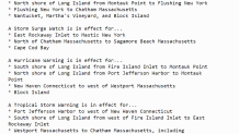
The first known evacuation orders came Saturday afternoon for a Long Island community. Suffolk County officials issued a voluntary evacuation order for Fire Island, encouraging anyone and everyone to leave the same day. The last boats off the island are scheduled to leave at 10:40 p.m.
"We are urging residents and visitors of Fire Island to come off the island, to leave Fire Island today for their own safety," Suffolk County Executive Steve Bellone said Saturday afternoon.
As of Saturday morning, New York City and northeastern New Jersey were no longer in the cone of concern as Henri, which triggered a series of hurricane, tropical storm and storm surge warnings and watches for much of the tri-state area as it charted a northeast course that could affect coasts from New York City to Long Island to Cape Cod. Track live radar and see latest conditions right here.
Damaging and destructive winds, heavy rains and dangerous storm surges are possible for those areas as well as parts of the city and Westchester County. Check the latest severe weather alerts for your neighborhood here.
A hurricane warning means hurricane conditions are expected within 36 hours; tropical-storm-force winds could also make for dangerous conditions. Storm surge warnings means there is a potential for life-threatening inundation from rising water moving inland from the coastline over the next 36 hours as well.
The combination of dangerous storm surge and high tide Saturday night will cause normally dry coastal areas to be flooded by rising waters, according to the National Weather Service. Those areas could see up to 5-foot storm surges if the peak surge hits around the time of high tide. Authorities on Long Island and Connecticut, where a state of emergency is in effect, are preparing intensely for potential direct impact.
New York City's Office of Emergency Management says it is closely monitoring Henri and its potential impacts. Open Restaurants outdoor seating and Open Streets will be suspended for Sunday.
Mayor Bill de Blasio is urging New Yorkers to stay home at peak storm times if they can, noting up to 6 inches of rain with 3-5 feet of coastal flooding is possible in northern Queens and the Bronx along with up to 50 mph wind gusts Sunday.
A northward to north-northeastward turn is expected Saturday, with a harder turn toward the north-northwest expected late Saturday. On the current forecast track, Henri is expected to make landfall in Long Island or southern New England late Saturday or early Sunday at or near hurricane strength.
Henri marks the first time since Hurricane Irene in 2011 that a hurricane watch or warning has been issued for parts of the tri-state area, NHC said. Long Island hasn't been directly hit by a hurricane since Gloria in 1985. Find out how to prepare here.
If Henri makes landfall in New England as a Category 1 storm, it would be the first time in three decades that a hurricane directly hit the region.
Utilities from Con Edison to PSE&G and National Grid said they were trimming trees Friday in anticipation of strong gusts that could tear down limbs and damage power lines. Extensive tree and power line damage is expected on Long Island and coastal Connecticut.
Some utility companies in the tri-state have warned customers they could be without power for up to 14 days, depending on the severity of the storm.
Live Radar: Track Latest Timing and Impacts for Tropical Storm Henri
Henri will also heavily impact the coast with storm surge, life-threatening rip currents, rough surf, and large-breaking waves developing Saturday, which could cause beach erosion. NHC warned that Henri-generated ocean swells could cause life-threatening surf and rip current conditions this weekend.
Much could still change over the next 24 hours as far as Henri's track is concerned, so stay with Storm Team 4 for all the latest need-to-know details.
Track the storm using our interactive radar below.
