Map: How the Thomas Fire Grew Into One of California's Largest Wildfires
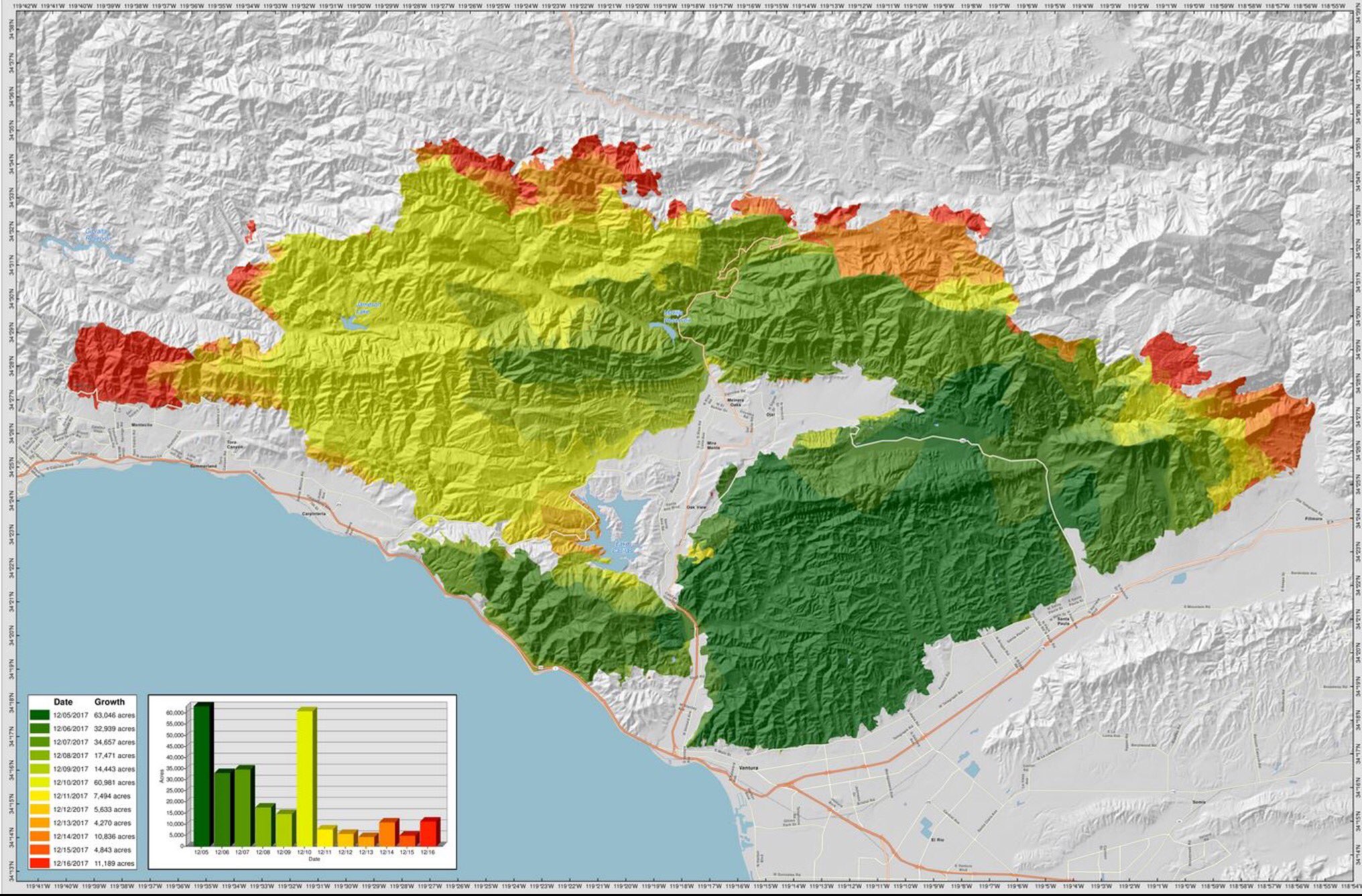
This map shows the advance of the Thomas fire through Dec. 16
By Jonathan Lloyd ••
The Thomas fire started Dec. 4 in Ventura County. Fanned by strong and shifting wind gusts, the fire grew quickly during its first 24 hours and eventually became the largest wildfire on record in California.
The map above shows the fire's progression through Dec. 20. It quickly burned more than 63,000 acres through Dec. 5. Dark green shades indicate the first days of the firefight. The fire then flared up Dec. 10, burning nearly 61,000 acres.
As of Dec. 19, the fire burned more than 271,000 acres in Ventura and Santa Barbara counties. It grew to nearly 282,000 acres and was contained Jan. 12.
Note: Click on the map or click here to see a larger view.
Lawrence Polin
Smoke from the Thomas fire rises in a distant plume.
Joe Preston
Smoke from the Thomas fire as seen from Thousand Oaks.
Mark Alexander
This photo was taken from Grimes Canyon Road, between Moorpark and Fillmore.
Amanda Ramirez
This photo of the Thomas Fire was taken from Fillmore.
Christine Gemperle
A look at the Thomas fire from an airplane high above Ventura County.
Deborah Skiscim
A view of the Thomsa fire smoke plume from Camarillo.
Pam
Smoke from the Thomas Fire can be seen from the Santa Barbara Mission.
Judy D
This view of the Thomas Fire smoke plume is from between Santa Paula and Fillmore.
Tim Farnsworth
This photo was taken Dec. 7, 2017 from the air base near Santa Barbara.
Abby Winger
Thomas fire smoke in the distance, as seen from Simi Valley.
Kevin Bryan Pangilinan
A view of the Thomas fire from Oxnard.
Zach Bloom
A view of the Thomas fire smoke Dec. 6, 2017 from downtown Ventura.
Zach Bloom
A view of the Thomas fire Dec. 6, 2017 from downtown Ventura.
KAthryn Dahms
A view of the Thomas fire Dec. 6, 2017 from Thousand Oaks.
Shiloh Litonjua
A view of the Thomas fire Dec. 6, 2017 from Ojai.


