Flash flood advisories and watches in effect for parts of Southern California
Flash flood watches and advisories are in effect across much of Southern California
By Staff Report ••
Telemundo
There is a potential for flash floods in some areas in southern California. NBC4 meteorologist Belen de Leon has has the latest.
What to Know
Rain is in the forecast through mid-week in Southern California.
Several inches of rain are possible, adding to record-setting rainfall from earlier this month that left hillsides saturated and prone to landslides.
Flash flood warnings and watches were in effect to start the week.
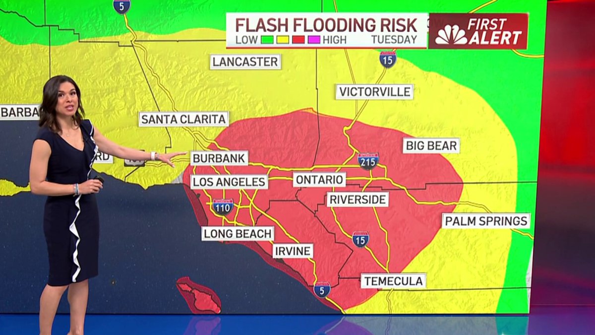
Steady rain continues to fall across much of Los Angeles County Tuesday as a three-day storm arrived, accompanied by numerous flash flood advisories and at least one evacuation warning as authorities urged caution on area roads.
“It’s going to be another soggy day today and the focus of the atmospheric river shifts east to the Inland Empire and Orange County,” said NBC4 meteorologist Belen de Leon.
De Leon said the steady rain is expected over the area until the early afternoon, then scattered activity through this evening. Most of the rain Tuesday will move into Riverside and San Bernardino counties, where flash flood watches and advisories are in effect.
Flash flood watches and advisories also are in effect for Orange County. In Los Angeles County, a flood watch is in effect.
An evacuation warning, urging residents to be prepared to evacuate, was issued for the area along Santa Maria Road north of Topanga Canyon Boulevard through Wednesday morning. The area in the Santa Monica Mountains is under threat of slides due to heavily saturated hillsides.
On Tuesday morning, the City of Huntington Beach tweeted the closure of PCH in both directions between Warner and Seapoint due to flooding.
Los Angeles County Public Works officials issued a “phase 2 debris flow forecast'' for the Land Fire burn area east of Sun Valley. The alert will be in effect until 9 a.m. Wednesday, according to the Los Angeles Fire Department, which said moderate flooding and mudflow/sediment deposition should be anticipated in the area of McDonald Creek, Del Arroyo Drive and La Tuna Canyon Road.
A strong storm will continue to impact #SoCal thru Wed morning. After a "lull" this afternoon/tonight, a second pulse of moderate/heavy rain is expected Tue and Tue night. There's also the potential for strong thunderstorms Tue/Tue night. #CAwxpic.twitter.com/5Zl5gAYOWO
“If conditions worsen, evacuation orders may be issued and evacuation sites will be identified,'' the LAFD said. “Take action now to be ready to quickly evacuate if you live on the streets along La Tuna Canyon Road with the borders of Horse Haven Street to the north, Martindale Avenue to the east, Penrose Street to the south, and Ledge Avenue to the west.''
A portion of Benedict Canyon Road was restricted to local access only due to a collapsing roadway. The "soft closure'" was in effect from Mulholland Drive to Hutton Drive, with Deep Canyon Drive suggested as an alternate route.
Mulholland Drive remained closed between Skyline Drive and Bowmont Drive due to severe road damage at four locations. That closure was expected to last weeks, officials said.
Rain is in the forecast through Wednesday, adding to the record-setting rainfall from an early February storm that left hillsides saturated and prone to landslides. The days-long early February storm triggered lands slides above and below Mulholland Drive and in Studio City, Beverly Crest and other hillside communities.
Watches and advisories are in effect for most of Southern California through Wednesday morning. A flood watch indicates excessive runoff from heavy rain, a possibility of mudslides and flooding in low-lying areas or neighborhoods near streams and creeks.
Getty
Vehicles drive through the rain on the 101 Freeway on February 19, 2024.
People walk in the rain on Hollywood Boulevard on Feb. 19, 2024 in Los Angeles. Credit: Getty
Mulholland Drive is closed due to landslides on Monday Feb. 19, 2024.
Khallid Shabazz
Mulholland Drive is closed due to landslides on Monday Feb. 19, 2024.
A backyard was underwater Feb. 5, 2024 in Sherman Oaks after steady rain. Credit: Chris Sturm
A backyard was underwater Feb. 5, 2024 in Sherman Oaks after steady rain. Credit: Chris Sturm
Chris Sturm
A backyard was underwater Feb. 5, 2024 in Sherman Oaks after steady rain.
Studio City, CA – February 05:Storm damage from mud, rock and debris flows along Lockridge road in Studio City, CA, has caused major damage to vehicles and houses in the area on Monday, February 5, 2024. Rain is expected to continue in Southern California over the next 12 hours. (Photo by David Crane/MediaNews Group/Los Angeles Daily News via Getty Images)
Getty
Studio City, CA – February 05:Storm damage from mud, rock and debris flows along Lockridge road in Studio City, CA, has caused major damage to vehicles and houses in the area on Monday, February 5, 2024. Rain is expected to continue in Southern California over the next 12 hours. (Photo by David Crane/MediaNews Group/Los Angeles Daily News via Getty Images)
Studio City, CA – February 05:Storm damage from mud, rock and debris flows along Lockridge road in Studio City, CA, has caused major damage to vehicles and houses in the area on Monday, February 5, 2024. Rain is expected to continue in Southern California over the next 12 hours. (Photo by David Crane/MediaNews Group/Los Angeles Daily News via Getty Images)
Khallid Shabazz/NBCLA
Crews remove a downed tree in Long Beach Monday Feb. 5, 2024.
Getty
LOS ANGELES, CA – FEBRUARY 04: People attending the Grammy’s run between the red carpet and a parking garage as another storm bears down at L.A. Live in Los Angeles Sunday, Feb. 4, 2024. (Allen J. Schaben / Los Angeles Times via Getty Images)
Jeffrey Hobgood
Getty Images
SANTA BARBARA, CALIFORNIA – FEBRUARY 04: A person walks along a flooded street as a powerful long-duration atmospheric river storm, the second in less than a week, impacts California on February 4, 2024 in Santa Barbara, California. The storm is delivering potential for widespread flooding, landslides and power outages while dropping heavy rain and snow across the region. (Photo by Mario Tama/Getty Images)
Getty Images
People stand in floodwater during a storm in Santa Barbara, California, US, on Sunday, Feb. 4, 2024. Hurricane-force winds whipped the seas off California, while heavy rains raised flood risks from San Francisco to San Diego, as another powerful Pacific storm arrived on the state’s doorstep. Photographer: Eric Thayer/Bloomberg via Getty Images
Getty Images
A person rides a bike through floodwater during a storm in Santa Barbara, California, US, on Sunday, Feb. 4, 2024. Hurricane-force winds whipped the seas off California, while heavy rains raised flood risks from San Francisco to San Diego, as another powerful Pacific storm arrived on the state’s doorstep. Photographer: Eric Thayer/Bloomberg via Getty Images
Getty
Stearns Wharf is shut down as the second and more powerful of two atmospheric river storms arrives to Santa Barbara, California on Feb. 4, 2024.
SANTA BARBARA, CALIFORNIA – FEBRUARY 04: Nate Stephenson takes photos of a boat which washed ashore as a powerful long-duration atmospheric river storm, the second in less than a week, impacts California on February 4, 2024 in Santa Barbara, California. The storm is delivering potential for widespread flooding, landslides and power outages while dropping heavy rain and snow across the region. (Photo by Mario Tama/Getty Images)
Wind blown palm trees during a storm in Santa Barbara, California, US, on Sunday, Feb. 4, 2024. Hurricane-force winds battered the seas off California, while heavy rains raised flood risks from San Francisco to San Diego, as another powerful Pacific storm arrived on the state’s doorstep. Photographer: Eric Thayer/Bloomberg via Getty Images
Getty
Ryan Coppenger, right, and Scott Larson, with the City of Long Beach ;Marine Bureau, collect bags of sand to be delivered to a lifeguard station that usually floods in preparations for upcoming storm in Long Beach on February 3, 2024. Coppenger and Larson also delivered sandbags to residents who needed them. Officials across Southern California are warning residents to prepare for what could be “life threatening and damaging flooding,” beginning Sunday. (Genaro Molina/Los Angeles Times via Getty Images)
Steve Brio
Clouds before the storm in Yorba Linda.
Getty
Water from heavy rains race down the LA River, carrying debris like this shopping cart with it. (Robert Gauthier/Los Angeles Times via Getty Images)
LONG BEACH, CA – JANUARY 31, 2024 – – Belmont Shore resident Don Kallenberg, 68, carries away sand bags to prep for any possible flooding from the upcoming storm at 72nd Place Lifeguard Station in Long Beach on January 31, 2024. Long Beach lifeguard Molica Anderson, 37, left, filled sandbags for residents. (Genaro Molina/Los Angeles Times via Getty Images)
A man sweeps floodwater inside his barbershop during a rain storm in Long Beach, California, on February 1, 2024. The US West Coast was getting drenched February 1, 2024 as the first of two powerful storms moved in, part of a “Pineapple Express” weather pattern that was washing out roads and sparking flood warnings. (Photo by David SWANSON / AFP) (Photo by DAVID SWANSON/AFP via Getty Images)
Long Beach , CA – February 01: Portions of the 710 Freeway was closed due to flooding in Long Beach on Thursday, February 1, 2024. (Photo by Brittany Murray/MediaNews Group/Long Beach Press-Telegram via Getty Images)
Long Beach, CA – February 01: A man swims chest-deep through flood waters with his cell phone near three cars that are submerged after rain flooded several areas of Long Beach from the first in a series of storms hits Southern California in the 2300 block of West Willow Street in Long Beach Thursday, Feb. 1, 2024. (Allen J. Schaben / Los Angeles Times via Getty Images)
Cars sit partially submerged on a flooded road during a rain storm in Long Beach, California, on February 1, 2024. The US West Coast was getting drenched February 1, 2024 as the first of two powerful storms moved in, part of a “Pineapple Express” weather pattern that was washing out roads and sparking flood warnings. (Photo by David SWANSON / AFP) (Photo by DAVID SWANSON/AFP via Getty Images)
Getty
Raindrops sit on a telescope at Griffith Observatory as storm clouds linger over the Los Angeles basin on Thursday, Feb. 1, 2024 in Los Angeles, CA. (Brian van der Brug / Los Angeles Times via Getty Images)
“When we get to Tuesday, the rain doesn’t stop. We’re going to add to the [rain] totals that have already fallen to the ground,” NBCLA forecaster Shanna Mendiola explained. “Even though it’s not going to be as much as last time, any little rain is going to cause some issues.”
As the LA County area expects 2 to 5 inches or rain and up to 6 inches of rain in the foothills, officials urged people to prepare for further damage from the rain.
“Due to the significant storm earlier this month, areas that were previously damaged may be more vulnerable to the impact of heavy rain, including mudslide areas,” according to a statement from the LA Emergency Management Department.
Authorities also warned people to avoid being in the ocean water by issuing a high surf advisory through Tuesday morning, adding dangerous rip currents would increase the risk of drowning especially at southwest and west-facing beaches.
A coastal flood advisory was also in effect until Tuesday morning in Ventura County beaches.