
The National Weather Service issued a trio of warnings Thursday to residents regarding the potential for severe weather.
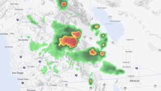
The National Weather Service in San Diego has issued a severe thunderstorm warning for northeastern San Diego County until 5:15 p.m. Officials said that at 4:22 p.m., a severe thunderstorm was located near state Route S2 between Shelter Valley and Agua Caliente, seven miles south of state Route 78 Between S2 And Borrego Springs Road, moving north at 35 mph. Wind gusts of up to 60 mph and quarter-size hail are possible. Damage to vehicles from the hail is expected, as is wind damage to roofs, siding and trees.
Flash-flood warnings are issued in northeastern and southeastern San Diego County until 5:45 p.m. in the south and a half-hour later to the north.
In North County, thunderstorms viewed on Doppler radar at 4:18 indicated heavy rain, with totals of 0.5 to 1.25 inches in 1 hour. Life-threatening lash flooding is ongoing or expected to begin shortly.
Get San Diego local news, weather forecasts, sports and lifestyle stories to your inbox. Sign up for NBC San Diego newsletters.
Locations likely to undergo flash flooding are areas near state Route 78 between S2 and Borrego Springs Road; between Borrego Springs Road and Ocotillo Wells; Borrego Springs; between Banner and S2; eastern Mount Laguna; S2 between Shelter Valley and Agua Caliente; Fish Creek Wash; S2 between Agua Caliente and Canebrake; S22 between Ranchita and Borrego Springs; Vallecito Creek Road; Ranchita; S22 between Borrego Springs and the Imperial County line; S2 between Canebrake and the Imperial County Line; Borrego Palm Canyon; S2 between state Route 79 and state Route 78; Agua Caliente; Shelter Valley; Canebrake; and Ocotillo Wells Vehicular Recreational Area.
In southeastern San Diego County, thunderstorms viewed on Doppler radar at 3:45 p.m. indicated heavy rain, with totals of 0.5 to 1 inches in one hour. Life-threatening flash flooding is ongoing or expected to begin shortly.
Locations likely to undergo flash flooding are areas near Interstate 8 between Boulevard and the Imperial County line, as well as northeastern Boulevard, state Route S2 Between Canebrake and the Imperial County line, and Jacumba.
