
An upper-level disturbance in the easterly flow was predicted to continue to bring significant moisture into Southern California Sunday and Monday, the National Weather Service said.
Radar and satellite were showing a few light showers Sunday morning moving rapidly southwest across San Diego County. The showers were embedded in a mass of mid and high clouds moving in from Arizona. Low clouds still covered much of the coastal areas and western portions of the inland valleys.
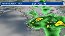
Extensive cloudiness, high humidity and cooler weather were expected to accompany this system, the NWS said.
Get San Diego local news, weather forecasts, sports and lifestyle stories to your inbox. Sign up for NBC San Diego newsletters.
Isolated thunderstorms were possible and may bring a threat of heavy rainfall rates and local flash flooding, mainly on Monday afternoon.
There was a small chance of an isolated thunderstorm over the coastal waters Sunday and Monday, though most of the thunderstorm activity would likely remain inland, the NWS said.
High temperatures along the coast Sunday were predicted to be 71-76 degrees with overnight lows of 62-67. Highs in the western valleys will be 76-81 and near the foothills, 81-86.

Mountain highs were expected to be 79-87 with overnight lows of 59-68. Highs in the deserts will be 95-100 with overnight lows of 76-81.
Local


For the middle of the week, drier south to southwest flow aloft was expected to limit any further showers and thunderstorms, confining any such development to the mountains and high deserts, the NWS said.
It was also predicted to be warmer, with daytime temperatures back to seasonally warm levels inland. The onshore flow was expected to keep the coast moderated with occasional marine clouds.
Late in the week, a return of monsoonal flow could spark more showers and thunderstorms into next weekend.
