
Monday night’s wild storm brought thousands of lightning strikes to Southern California and substantial rainfall to a very dry San Diego County. Here’s a closer look at the October 2021 storm, by the numbers.
How Many Lightning Strikes Were There in SoCal?
The National Weather Service in San Diego said on Tuesday morning that the cloud-to-lightning counts for the past 24 hours (7 a.m. Monday to 7 a.m. Tuesday) were:
Get San Diego local news, weather forecasts, sports and lifestyle stories to your inbox. Sign up for NBC San Diego newsletters.
- San Diego County: 524 lightning strikes
- Los Angeles County: 171 lightning strikes
- Western Riverside County: 102 lightning strikes
- Orange County: 63 lightning strikes
Across all of Southern California -- including coastal areas and eastern deserts -- the NWS tracked approximately 4,000 lightning strikes during the storm on Oct. 4, 2021.
“Even though the number of lightning strikes came as a surprise to many, we cannot predict lightning,” explained NBC 7 meteorologist Sheena Parveen. “We can predict thunderstorms (which have lightning), but not how much lightning may occur.”
The wild weather sparked some lightning-related fires across San Diego and caused some damages. You can read about that here.
Oct. 4 Storm: San Diego's Rainfall Totals
Parveen said Tuesday that precipitation in San Diego on Oct. 4 was 0.47 inches. Normally for this date, that stat is just 0.01 inches.
“Yesterday set a precipitation record at San Diego International Airport,” she added.
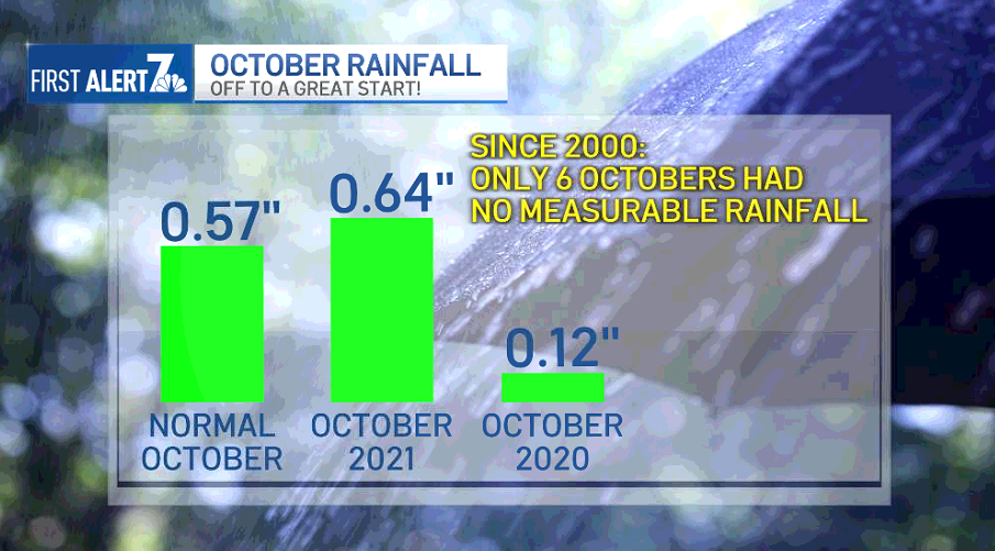
Parveen said the 24-hour total, as of 7:55 a.m. Tuesday, was 0.64 inches of rain (some came down after midnight, as you may have noticed while sleeping).
Local


With extremely dry conditions across the state, rainfall was certainly needed.
Parveen said that so far this year, San Diego County has gotten a total of 4.73 inches of rain. The normal amount of rainfall by this time of the year for our region is 6.86 inches, so the rainfall deficit is 2.13 inches.
So, how did the rainfall stats break down across the county? The NWS has a full report here, but here are some highlights for the areas that got the most rain from this wild storm over the past 24 hours:
- Granite Hills: 0.83 inches
- Deer Springs: 0.81 inches
- Fashion Valley: 0.72 inches
- Lake Murray: 0.71 inches
- Kearny Mesa: 0.68 inches
- Palomar Observatory: 0.65 inches
- San Diego International Airport: 0.64 inches
- Fallbrook: 0.63 inches
- Encinitas: 0.61 inches
- Rancho Bernardo: 0.61 inches
Parveen said the reason there were so many widespread storms Monday was because an area of low pressure was moving across the region.
“Areas of low pressure have more instability,” she explained. “More instability means more thunderstorms. “
Despite October being known as a month for fire-prone weather in San Diego County, Parveen said that since 2000, there have only been six October months with no measurable rainfall in San Diego County.
So, it’s not uncommon for the region to get rainfall like this during this time of the year.
“Out of the past 21 years, 15 of those had measured rain for October, and some had several inches,” she added.
PHOTOS: San Diego's Powerful Storm, Captured in Striking Pics
At Storm's Peak: 13,000+ Without Power in San Diego County
As of 10 p.m. Monday, San Diego Gas & Electric reported more than two dozen power outages impacting more than 13,000 customers. Severe weather caused many of the outages, SDG&E said.
As of 8 a.m. Tuesday, SDG&E’s outage map showed some outages still impacting some communities, but nothing close to the impact felt Monday night.
What's Next? Cooler, Comfortable Fall Temps Will Last Through the Weekend
Parveen and NBC 7 meteorologist Brian James both said that starting Tuesday, San Diego County will see much cooler temps.
“What a difference a day makes!” Parveen said Tuesday morning. “After yesterday's heavy rain and thunderstorms, this morning we're dry and will remain dry for the remainder of the day. High temperatures will also be slightly cooler today.”
An onshore flow will keep that pattern going for a while, too.
“This will begin our cooling trend through the rest of the week,” Parveen explained. “Get ready to see and feel some changes.”
The onshore flow will persist through the end of this week and into the weekend.
And you may need to grab a sweater.
“This will increase clouds and keep temperatures much cooler, feeling more like fall with a chill in the air,” Parveen said.
She said the coolest temperatures will be felt on Friday.
And, a little more rain is expected toward the end of the week.
According to NBC 7’s First Alert Forecast, there’s a chance another weak weather system will move through San Diego County, bringing the possibility of light rain Thursday night and Friday.
The weekend will remain cool, with milder weather well into Sunday.
And, come next week, the fall feeling is likely to last.
“We may see a fairly active weather pattern next week, too,” Parveen explained.
