
What to Know
- Back-to-back-to-back storm systems will bring rain through the weekend with minimal breaks in between days
- Brrr! It will be extremely cold through Friday, with temperatures 10 to 15 degrees below average for this time of year at the coast and 15 to 25 degrees below normal in the valleys and deserts
- Once the storms pass after Sunday, much of San Diego County is forecasted to have received 4 inches or more of rainfall
Downpours with the potential to cause dangerous flooding are on the way for San Diego County as what could be several feet of record-breaking snowfall continues to blanket the region's mountains on Thursday.
Widespread, spotty showers will make for a wet morning commute in much of the county Thursday. NBC 7 meteorologist Dagmar Midcap said the strong winds we experienced Wednesday are sliding out of center stage to make room for heavy rain to end our week.
Brrr! Get ready for some low temperatures Thursday:
Get San Diego local news, weather forecasts, sports and lifestyle stories to your inbox. Sign up for NBC San Diego newsletters.
Thursday Temperatures:
- Coast - 55 degrees - rain / gusty
- Inland - 52 degrees - rain/ gusty
- Mountains - 33 degrees - winter storm warning
- Deserts - 54 degrees - rain / gusty
Wet weather is forecasted to last through the weekend. Rain will be light, off-and-on, through Thursday. NBC 7 Meteorologist Sheena Parveen said it'll be quite an active weather pattern.
Local


"Kind of waves of rain, so scattered in nature and for the mountains, we’re dealing with snow," Parveen said. "Snow levels this morning can be dropping about 2,500 feet."
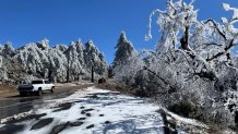
Two to five feet of snow may occur in higher elevations.
"In our mountains, this is going to be potentially historic snowfall, mostly above 4,500 feet," Parveen said in her forecast. "This is the coldest storm of the season."
The system even brought snow to usually balmy Southern California. The weather service office in San Diego issued its first-ever blizzard warning, covering the mountains of San Bernardino County from early Friday until Saturday afternoon. Back in 1989 the NWS issued a statement that warned of "blizzard conditions" with that particular extreme weather system. Although it was not called the same thing, it meant the same thing as today's blizzard warning.
On Thursday, the first signs of snow on the ground were in between Ramona and Santa Ysabel — elevation there is around 2,800 feet.
Then, another storm system in the form of an atmospheric river will take aim at San Diego County -- and that's when the downpours begin. The heaviest rain is expected Friday and Saturday.
Atmospheric rivers are plumes of moisture in the sky over the ocean. Once storms draw moisture from the rivers in the sky, they're capable of producing long periods of significant precipitation. The weather phenomenon is behind some of the wettest winters on record in California.
Once the storms pass after Sunday, much of San Diego County is forecast to have received an average of 4 inches of rainfall -- more in some areas.
But first... "It’s going to be a very messy weather pattern for the next few days," Parveen warned.
For the next week, each San Diego microclimate will experience its own wild weather. Here's what to expect:
Weather in San Diego's mountains and deserts:
Three-day mountain precipitation totals:
- Santa Ysabel: 2.3 inches
- Pine Valley: 1.99
- Campo: 1.72 inches
- Descanso: 1.46 inches
The mountains are expected to receive two to three inches of rain Wednesday evening into Thursday. Snow levels are expected to rise to 5,000 to 5,500 feet Friday night, the NWS said.
The coldest weather will be experienced in San Diego's mountains, which are under a winter weather warning through 3 p.m. Saturday with snow possible at elevations as low as 2,000 feet.
That's unusually low for San Diego County, meaning towns like Alpine could see some snowfall. A mix of snow and hail fell at 2,200 feet above sea level at Crawford Overlook in the Anza-Borrego Desert State Park Wednesday, according to the park's official Twitter account.
The CHP says chains are required on State Route 79 from Interstate 8 to Engineer's Road, and from Engineer's Road to Inspiration Point/Desert View Park. Additionally, the snow gate on Sunrise Highway from SR-79 to mile marker 27.5 is closed.
In Julian on Friday, plenty of snow was falling and accumulated on the roads. Several snow plows were spotted, but with how much snow was falling, the roads turned white again fast. Several businesses in the small community were o closed — and not many visitors were in town around noon.
At each elevation, we had someone tell us this is the most snow they’ve seen (respectively— Santa Ysabel, Wynola and Julian) in the last several years.
Weather in San Diego's inland valleys:
Three-day valley precipitation totals:
- Alpine: 1.41 inches
- Valley Center: 1.39 inches
- Skyline Ranch: 1.07
- Ramona: 1.06 inches
With all this weather action, several alerts have been issued by the National Weather Service.
In addition to mountain communities getting clobbered by snow, some of the county's inland valleys have the potential to be impacted, as well. With snow slated to reach elevations of 2,500 feet, NWS issued a winter weather advisory for such areas through 10 a.m. Thursday.
"Even if you don't see it accumulating, you very well may see it falling," Parveen said in her 6:30 a.m. forecast.
A flood watch will be in effect for inland valleys from Friday afternoon through Saturday evening. NWS warns excessive runoff may cause rivers, creams and streams to flood.
And with more wind slated to hit the region, a wind advisory will be in effect from 6 a.m. Friday to 6 a.m. Saturday. South winds will breeze by at 20 to 30 mph, with gusts having the potential to reach speeds of 45 mph.
Weather for San Diego's coast:
Three-day coastal precipitation totals:
- Carlsbad: .75 inches
- Kearny Mesa: .48 inches
- Vista: .46 inches
- San Onofre: .44 inches
This wet weather will just continue to dump buckets of rain over the region, including at the coast.
These communities will be under a flood watch from Friday afternoon through Saturday evening due to the excessive rainfall.
Additionally, coastal areas will be impacted by the same wind advisory that will affect the valleys. This advisory has been issued for 6 a.m. Friday through 6 a.m. Saturday.
School Closures:
The frosty weather forced some mountain area schools to issue a snow day on Wednesday and Thursday. School closures include:
- Julian Union Elementary School District
- Julian Union High School District
- Mountain Empire Unified School District
- Spencer Valley School District
Snow levels will elevate to 2,500 feet by Thursday and the greatest chance for large amounts of snowfall is on Friday. Winds will also increase again on Friday, making for hazardous driving conditions. By the time Saturday's atmospheric storm reaches San Diego County, snow levels will elevate to 5,000 feet.
When all is said and done, some areas could see two to eight inches of snow.
All this wild weather will begin to tame on Sunday for at least a few days of dry weather, Parveen said.
