
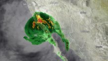
Hurricane Kay made landfall on a sparsely populated peninsula on Mexico’s Pacific coast Thursday before weakening into a tropical storm as it traveled on a path forecasters said might bring its rains to southernmost California by the weekend.
The storm’s maximum sustained winds weakened to near 70 mph, and Kay was expected to continue weakening in the coming hours.
The eye of the storm came ashore as a hurricane near Bahia Asuncion in Baja California Sur state. Kay was forecast to move back out over cooler water, weakening it.
Get San Diego local news, weather forecasts, sports and lifestyle stories to your inbox. Sign up for NBC San Diego newsletters.
While Hurricane Kay is expected to stay well off California's coast, it will bring gusty winds and rain to San Diego County as soon as Thursday, NBC 7 Meteorologist Sheena Parveen said.
"Finally. This is much-needed rain. It's also going to break our hot spell," Parveen said in NBC 7's First Alert Forecast.
Local

Parveen predicts rain totals before Kay moves out of the region could be up to an inch at the coast and in the valleys and two inches in the mountains. There still may be some scattered showers on Thursday but the brunt of the storm is expected Friday.
With the hurricane came a slew of alerts for San Diego County. The NWS issued a flood watch from Friday afternoon through Saturday evening for our San Diego County mountains and deserts. A high wind warning was issued for the entire county from 6 a.m. to midnight Friday as gusts reached the 25 to 45 mph range. For the seas, a gale watch was in effect Friday morning through Saturday evening.
And, of course, an excessive heat warning, which was issued last Wednesday, was still in effect until 8 p.m. Friday as the lengthy heat wave tried to keep its grip on San Diego County.
Hurricane Kay gained strength Wednesday as it tracked northward along the Baja California coastline towards the United States. The hurricane was about 200 miles offshore and forecasters don't expect the hurricane to make land, although it could brush the Baja peninsula.
The hurricane was approaching San Diego more quickly than originally anticipated. Earlier models didn’t have the hurricane reaching the waters off the U.S.-Mexico border until Friday. But the first signs of rain touched down Thursday morning, bringing quick, spotty showers to parts of San Diego before quickly letting up.
The hurricane was centered about 115 miles northwest of Cabo San Lazaro early Thursday. By the time Kay reaches the U.S.-Mexico border, winds are expected to be around 45 miles per hour and as the storm continues north, it will turn sharply away from the coast and winds will die down to about 35 mph, according to current mapping predictions.
"As we head into Thursday, that could still be a hurricane but as it gets closer, it's going to weaken quite a bit," Parveen said.
In anticipation, San Diego County and Cal Fire are providing free sandbags to residents in unincorporated areas to prevent flooding and erosion. Bring your own shovel to any of these locations to get bags and/or sand. In Chula Vista, Residents elsewhere in the county can check here to see where sandbags are available to them.
San Diego County and most of the West has been overtaken by a grueling heat wave for the last week, which has sent temperatures into triple digits, broken record heat and prompted calls to conserve energy in California as customers nearly max out the power supply.
Rotating power outages were narrowly avoided on Tuesday but a Flex Alert was in effect again Wednesday.
The extreme weather has also elevated the region's fire risk. The closest wildfire to San Diego County was the Fairview fire in the Hemet area, which has scorched 5,000 acres and killed a father and daughter who were attempting to escape.
