
High pressure was predicted to build into California over the Labor Day weekend, bringing hot weather inland, the National Weather Service said.
The marine layer was expected to become shallower and less extensive, with limited clouds and fog confined mainly to coastal areas, forecasters said.
A south swell was forecast to arrive at county beaches this weekend, elevating surf, and creating dangerous swimming conditions, the NWS said.
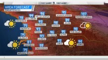
High temperatures along the coast Saturday were predicted to be 77-82 degrees and inland 86-91 with overnight lows of 62-67. Highs in the western valleys will be 90-95 and 94-99 near the foothills with lows of 64-72. Mountain highs were expected to be 89-96 with overnight lows of 64-73. Highs in the deserts will be 105-110 with overnight lows of 81-86.
Get San Diego local news, weather forecasts, sports and lifestyle stories to your inbox. Sign up for NBC San Diego newsletters.
"Coastal areas and the San Diego valleys should largely escape the heat, although Saturday should be the warmest day for those areas as it appears a coastal eddy may develop for Sunday, lowering temperatures a few degrees," the NWS said.
The high pressure was predicted to shift east into the Great Basin on Tuesday, putting Southern California into a good position to welcome monsoon moisture back into the region, forecasters said.
Local


Monsoon thunderstorms were likely to return by the middle of next week for the mountains and deserts ahead of a developing West Coast trough and cooling trend late next week.
Thunderstorms could return for the mountains and deserts around Wednesday and may continue through Friday.
For next weekend, a trough may develop off the West Coast, which would bring stronger onshore flow, a deeper marine layer, and cooler temperatures.
